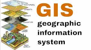
"geographic information system" 단어의 한국어 의미
"geographic information system"는 영어로 무엇을 의미하나요? Lingoland와 함께 이 단어의 의미, 발음 및 구체적인 사용법을 알아보세요
geographic information system
US /ˌdʒiː.əˈɡræf.ɪk ɪn.fɚˌmeɪ.ʃən ˈsɪs.təm/
UK /ˌdʒiː.əˈɡræf.ɪk ɪn.fɚˌmeɪ.ʃən ˈsɪs.təm/

명사
1.
지리 정보 시스템
a system designed to capture, store, manipulate, analyze, manage, and present all types of geographical data
예시:
•
We used a geographic information system to map the distribution of endangered species.
멸종 위기종의 분포를 매핑하기 위해 지리 정보 시스템을 사용했습니다.
•
Understanding a geographic information system is crucial for urban planning.
지리 정보 시스템을 이해하는 것은 도시 계획에 매우 중요합니다.
동의어:
Lingoland에서 이 단어 학습하기